2.1 Volcano-tectonic history
Southwest Japan is subdivided into two zones, the Inner and Outer zones, bound by the Median Tectonic Line (Figure 1a). The Outer Zone is composed of three trench-parallel tectonic provinces: The Shimanto belt, a Jurassic to Paleogene accretionary prism composed of sandstones and shales, is the southernmost and largest of these provinces (Figure 1a; Wallis et al., 2020).
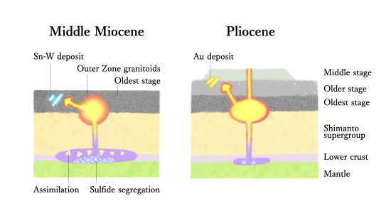
Granitoids of middle Miocene age (17–12 Ma) are widely distributed in the Outer Zone of Southwest Japan, including the South Kyushu area (Figure 1b; Kimura et al., 2005). These are called Outer Zone granitoids and are classified as the ilmenite series (Ishihara and Matsuhisa, 1999). Most of these granitoids intrude the sedimentary rocks of the Shimanto belt (termed the Shimanto Supergroup). The Outer Zone granitoids are sometimes subdivided into two types: I-type granites, with hornblende-bearing mineral assemblages distributed in the northern area, and S-type granites, with cordierite- or garnet-bearing assemblages distributed in the southern area (Nakada and Takahashi, 1979). Tectonic reconstruction suggests that the Shikoku Basin, a relatively young part of the Philippine Sea Plate, was located further west in the middle Miocene, subducted beneath Kyushu (Mahony et al., 2011). Formation of the Outer Zone granitoid is estimated to be related to the shallow subduction of the hot Shikoku Basin, with a relatively fast convergence rate (>10 cm/year; Kimura et al., 2005).
South Kyushu experienced a cessation of subduction-related volcanism around 12 Ma (Kamata and Kodama, 1994), the cause of which is a topic of ongoing debate. The volcanic activity resumed at approximately 7.5 Ma, along the western margin of South Kyushu (Mahony et al., 2011), and migrated eastward to the Kagoshima Graben, where the present volcanic front is located. Until the Pleistocene, volcanism was characterized by the formation of voluminous andesite lava plateaus, followed by basaltic to dacitic explosive and caldera-forming volcanism in the Quaternary period. These volcanic rocks lie unconformably on the Shimanto supergroup and Outer Zone granitoids. Tectonic reconstruction indicates that, during this period, the West Philippine Basin, an older part of the Philippine Sea Plate, was subducting beneath South Kyushu, with a moderate convergence rate (approximately 4 cm/year; Mahony et al., 2011).
2.2 Mineralization
Au mineralization
Epithermal Au deposits are widely distributed throughout the western half of South Kyushu. The mineralization in this region includes low-sulfidation (LS)-type Au-bearing quartz veins, represented by the Hishikari deposit (Izawa et al., 1990), and high-sulfidation (HS)-type disseminated Au in massive quartz ore bodies, represented by the Akeshi deposit (Hedenquist et al., 1994; Ishida et al., 2021). Mineralization ages (5–0.5 Ma) are younger in the eastern part of the province, consistent with the eastward shift of the volcanic front over the past 7.5 Ma (Izawa, 1992; Watanabe, 2005). The currently operating mines include the Hishikari (LS; >300 t Au) and HS deposits of Akeshi, Iwato, and Kasuga in the Nansatsu area (>26 t Au) (Watanabe, 2005). The historically mined deposits include Kushikino (low- to intermediate-sulfidation; 56 t Au), Yamagano (LS; 28 t Au), and Ohkuchi (LS; 22 t Au) (Watanabe, 2005).
2.3. Nansatsu volcanic rocks
For the middle Miocene–Pleistocene volcanic rocks in Nansatsu, different unit classifications have been used in different studies, which may confuse readers. In this study, we summarized the history of the unit classification of these volcanic rocks and described their petrology. The most comprehensive study of igneous rocks in the Nansatsu area was conducted by MITI (1985), who classified the volcanic rocks into late Miocene Lower and Upper Nansatsu Groups, early Pliocene Nansatsu Middle Volcanics, and late Pliocene–Pleistocene Nansatsu Younger Volcanics. Kuroiwa et al. (1989a) conducted an in-depth study of the Nansatsu Group and re-classified it into four units, and indicated that three of the units (Hiramichiyama, Nishinooka, and Akime formations) were formed in the late Miocene; additionally, they suggested that one unit (Kasasakurose Andesite) was formed during the middle Miocene period, owing to the fact that this unit was intruded by the outer zone granitoids (Yamamoto et al., 1970). Uto et al. (1996) first used the terms “oldest/older/middle/younger stage Nansatsu Volcanic rocks,” corresponding to the units found in the northern Satsuma Peninsula region (Hokusatsu area). These terms continue to be used, although the “Oldest stage Nansatsu volcanic rock” has been omitted in recent compilations (Kawanabe et al., 2004; Geological Survey of Japan, 2015), without reasonable justification. In this study, we have used the terms “Oldest/Older/Middle/Younger stage Nansatsu Volcanic rocks,” according to Uto et al. (1996). The correspondence relationships for each unit are explained in the following paragraphs. All stages of the Nansatsu volcanic rocks overlay the Shimanto Supergroup unconformably.
The Oldest stage Nansatsu volcanic rocks corresponded to the Kasasakurose andesite described by Kuroiwa et al. (1989a). It consists of pyroxene andesitic lava with tuffaceous conglomerate, sandstone, and silt. The oldest stage rocks generally undergo strong hydrothermal alteration, but the fresh rocks contain plagioclase and clinopyroxene phenocrysts (Kuroiwa et al., 1989a). Although no dating data for the Oldest stage rocks are available, they are considered to have been formed in the middle Miocene, owing to the fact that the unit was intruded by the acidic rocks of the Outer Zone granitoids dated between 15 and 12 Ma (Yamamoto et al., 1980; Kuroiwa et al., 1989a). To date, no mineralization has been associated with this volcanic rock unit.
The Older stage Nansatsu volcanic rocks correspond to the Hiramichiyama, Nishinooka, and Akime formations (Kuroiwa et al. 1989a) and the eastern part of the Lower and Upper Nansatsu Groups (MITI, 1985). It consists mainly of pyroxene andesitic to dacitic lava and pyroclastic rock with tuffaceous mudstone, sandstone, and conglomerate, and overlies the Shimanto Supergroup (Morozuka Group) and the Outer Zone granitoids unconformably (Kawanabe et al., 2004). The lowermost pyroxene hornblende andesite has been dated at 7.6 ± 2.3 Ma (K-Ar dating; MITI, 1985). The upper pyroxene hornblende andesite has been dated at 6.4 ± 0.3 Ma (K-Ar dating), and the pyroxene andesite has been dated at 5.9 ± 0.8 Ma (K-Ar dating) and 6.16 ± 0.45 Ma (fission-track dating) (MITI, 1985), which agree with the results of paleomagnetic dating conducted by Takeda et al. (2001). The Older stage Nansatsu volcanic rocks have generally undergone strong hydrothermal alteration and host many gold deposits distributed in the Nansatsu district (e.g., Kasuga, Iwato, and Kago deposits).
The Middle stage Nansatsu volcanic rocks correspond to the Nansatsu Middle Volcanic Rocks analyzed by MITI (1985). They consist of hornblende andesite lava and pyroclastic rocks with minor tuffaceous conglomerate and mudstone. The Middle stage Nansatsu volcanic rocks overlie the Cretaceous Shimanto Supergroup and the Older stage Nansatsu volcanic rocks unconformably, and are overlain by the Younger stage Nansatsu volcanic rocks. The degree of alteration is weaker in the Middle stage rocks than the Older and the Oldest stage Nansatsu volcanic rocks. MITI (1985) deduced that the rocks had an age of 2.28–4.56 Ma, using fission-track dating, which agrees with the results of paleomagnetic dating conducted by Takeda et al. (2001). The Middle stage rocks host the Akeshi deposit (Metal Mining Agency of Japan, 1993) and are contemporaneous with gold mineralization in this area (Takeda et al., 2001; Tindell et al., 2018).