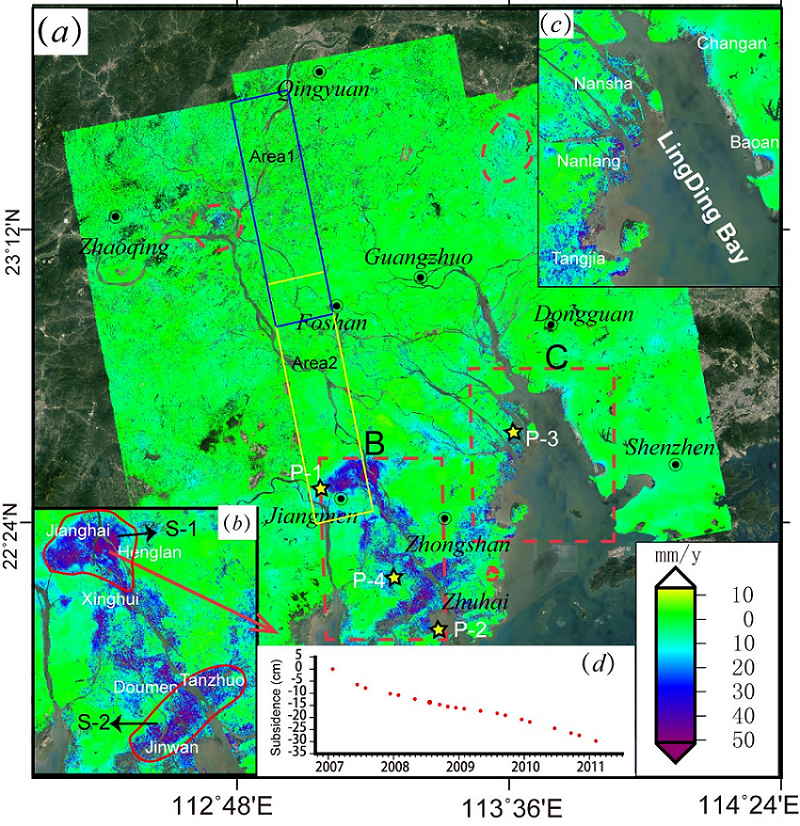
Surface deformation in the PRD is caused by the joint force of natural geological evolution factors and human activities. Natural factors include sediment consolidation, tectonic activity, sea level rise and tidal load (Hu et al. 2018). Human activities are land reclamation, groundwater extraction, engineering construction and so on (Wu et al. 2016; Wang et al. 2017). Based on the InSAR measurement, we analyze the relationship between the subsidence and natural factors and human interference.
4.1 Natural factors
4.1.1 River distribution and coastline evolution
Superimposing the river distribution map of the PRD on the deformation rate map (see Fig. 7a), we also find that the subsidence areas are distributed along rivers, especially the front part of the PRD, where the river networks are dense (Chen et al. 2012). Moreover, the map of the coastline changes over the past 6,000 years (see Fig. 7b) show that almost all the subsidence areas are distributed in the regions formed in the past 1000 years. The coastline of the PRD continues pushing outward as silt keeps on depositing at the junction of land and sea. The geological structure formed by subsidence, however, is inherently unstable. The PRD is mainly composed of soft soil layers with high water content and compressibility, poor permeability, low bearing capacity and shear strength (Gebrechael et al. 2018), which easily leads to surface deformation. Most of the soft soil layers formed by sediment deposition are distributed along rivers, so subsidence usually occurs along rivers and in the front part of the delta.
The formation time of the coastline also has influences on the stability of the ground structure, as newly formed soil has a shorter consolidation period and may bring larger subsidence. The land subsidence of the PRD has a high correlation with the distribution Quaternary sediments (Chen et al. 2012). This pattern has been validated in various delta regions of the world without man interventions.
For example, in the Fraser River Delta of Canada, the surface slowly sinks with an annual rate of 1–2 mm/y (Mazzotti et al. 2009), which is mainly caused by the consolidation of shallow Holocene sediments (soft soil). In the Mississippi Delta, the subsidence rate due to soil compaction is relatively large. The settlement speed of the soft soil area formed thousands of years ago is about 5 mm/y, and that of the area formed in the past tens to hundreds of years exceeds 10 mm/y (Törnqvist et al. 2008).
4.1.2 Geological structure
Some areas in the front part of the PRD has no significant settlement (see Fig. 7). These areas are the bedrock distribution areas (β) (see Fig. 8a). Before the modern delta were formed (6,000 years ago), these bedrock distribution areas were isolated islands, and most of them were composed of bare rocks. As the coastline moved outward, those islands gradually merged into the land. The geological structures of these regions are stable. As Fig. 8a and 7b show, there is a strong positive correlation between the thickness of the soft soil and the deformation rate. Similar results were got in the research on the Ganges-Brahmaputra Delta (Higgins et al. 2014). The relationship between the compressible soil layer thickness and subsidence rate in the Tiber River delta was also investigated with the borehole data and the ground-shaped variables obtained from the PS-InSAR technique (del Ventisette et al. 2015). Therefore, the soft soil thickness can be inverted by the correlation between surface deformation and drilling data.
Soft soil is mainly distributed along rivers and low-lying areas of the delta, where the erosion caused by sea level rise is serious. In Fig. 8c, the green area is lower than the average sea level, and it accounts for more than 1/3 of the entire onshore delta. The subsidence in the area below the sea level is outlined by the yellow line in Fig. 8d. The comparison between Fig. 8c and Fig. 8d shows that the land subsidence in the front and middle parts of the PRD concentrates in the area below the mean sea level. The annual average tidal range of the Pearl River Estuary is 1.0-1.7 m, and the load generated by tides and storm surges can cause settlements of a few millimeters to centimeters. The low-lying areas, affected by tides, rain, sea level rise, storms and floods, are also the areas accommodating severe subsidence disasters. According to the Intergovernmental Panel on Climate Change (IPCC), the sea level had risen 0.19 m (1.7 mm/y) between 1901 and 2010. And the rise is accelerating (Zhang and Church 2012). These low-lying areas would suffer from both seawater erosion and surface subsidence in the future.
4.2 Human activities
4.2.1 Reclamation
In the 1960s, the large-scale reclamation in the PRD rapidly changed the shape of the coastline. The reclamation rate between 1970 and 1995 reached 21 km2/y and then slowed down in the past 10 years. We collect the coastline data from 1850 to 2015 with a time span of 165 years, and depict the changes in Fig. 9. The blue line is the PRD coastline in 1850, and the red lines are the coastlines of different periods. In the past 165 years, the coastline and landforms have undergone tremendous changes. A large area of land has been reclaimed from waters and tidal flats. In particular, about 1,258 km2 water area of the estuary bay has been reclaimed in the past 45 years (from 1970 to 2015). As the shoreline gradually moved towards the sea, more than 20 islands gradually merged into the mainland. By 2015, almost all the tidal flats in 1850 had been reclaimed into land.
As shown in Fig. 9, the reclaimed areas are also the most severely settlement area (subsidence rate: 50 mm/y), including the coastal areas of Zhuhai, Guangzhou, Dongguan and Shenzhen. Most of these areas were reclaimed in the last 30 years (Xu et al. 2016; Huang and Zhang 2004), so the geological structure is unstable. Furthermore, the landfill materials are sediments, which causes subsidence by self-consolidation.
We select two areas, Nansha district of Guangzhou city and Jinwan district of Zhuhai city (outlined by the yellow dotted line in Fig. 9) to analyze the relationship between the subsidence and reclamation in detail. As shown in Fig. 10, these two areas were reclaimed from the sea a few decades ago. In 1984 (see Fig. 10a), Longxue and Hengmen were small islands, but they gradually expanded outwards and formed the basic shape of the current island in 2016 (see Fig. 10b-e). The area of Longxue island cofferdam had increased about 150 times in 35 years. The newly reclaimed regions have serious subsidence, and the maximum subsidence rate is 75 mm/y (see Fig. 10f). Figure 10g-k show the variation of the reclaimed region in Jinwan district of Zhuhai city, where two small subsidence cones are obvious (see Fig. 10l). Gaolan island, which was an island before 2004, became connected to the land in 2010 (see Fig. 10j). The connection area accommodates the subsidence cones, where the maximum subsidence is 87 mm/y (see Fig. 10l).
Many countries, such as the Netherlands (Hoeksema 2007), the United Kingdom (Wali 1975), Japan (Suzuki 2003) and Singapore (Douglas and Lawson 2003; Xu et al. 2016), have reclaimed land from the sea for the coastal industries and agricultural development, as well as for storm defense. Surface deformation monitoring in the Nile Delta and the Tiber Delta indicates that the reclaimed area is the most severely subsiding area (Stramondo et al. 2008; Marriner et al. 2012). So the long-term monitoring of the reclaimed area in the PRD is necessary to ensure the safety of the construction there.
4.2.2 Other human interventions
The PRD region is an economic center of south China, where densely distributed factories, buildings, farmlands, and fisheries. The natural evolution and reclamation are the main factors for land subsidence in the PRD, but the land subsidence rate in some areas is as high as 70 mm/y, which can not only be caused by natural factors. We took the subsidence cone S-1(see Fig. 4b) in Jianghai District of Jiangmen City as an example to analyze the relationship between human activities and surface subsidence. As shown in Fig. 11b, the maximum subsidence rate is 80 mm/y.
The field investigation found that fish ponds are widely distributed in the coastal area of Jianghai (Fig. 11a), where large area land subsidence occurred. Aquaculture needs great amount of freshwater. Aggressive extraction of groundwater leads to the rapid drop of the groundwater level and causes subsidence, even settlement funnels. Settlement funnel S-1 is 160 km2 and is sinking 50 mm/y. Two profiles along the settlement funnel S-1 (Fig. 11b), ab and cd, are used to analyze the settlement characteristics and their average settlement rates are shown in Fig. 12.
The subsidence caused by excessive groundwater extraction is common in delta areas. In the Mekong Delta, the average land subsidence rate has reached 16 mm/y as more than 250,000 hectares of land has been converted from rice fields to shrimp ponds since 2000 (Erban et al. 2014). Oil and groundwater extraction play a key role in the land subsidence in the modern Yellow River Delta, and the land subsidence caused by aquaculture is up to 250 mm/y (Higgins et al. 2013). The land subsidence caused by human activities usually has a small involved area, about a few square kilometers to tens of square kilometers. The area of the subsidence funnel S-1 in the PRD is up to 160 km2, such magnitude is of rare occurrence in other deltas.
Natural factors coupled with human activities cause the subsidence in the PRD. The evolution of the PRD determines the location of the subsidence areas, and human activities have become the direct cause of the settlement. Therefore, in addition to the subsidence caused by natural factors, we should pay more attention to the subsidence caused by human activities.