2.1 Study area
The scenarios were tested for Myanmar’s Tanintharyi Region in the south, which is a hub for natural resource extraction of tin, coal, offshore gas and timber (K. M. Woods & Naimark, 2020). Dawei district (Fig. 1) represents all relevant land uses in the area and has been a hotspot of different developments for both economic development and the conservation of natural resources in the past (DOP, 2014). Major ethnic groups in the region are Burmese, Karen as well as Mon, and there are also several smaller ethnic groups and subgroups. The Karen National Union (KNU) is one of Myanmar’s most important ethnic armed organizations in terms of size of their army and governed territories (K. M. Woods, 2019b). They have a functioning governing body with several departments and policies on land, forests, environment, and economy. Under their jurisdiction, they recognize land rights of customary land users and communities (K. M. Woods, 2019b).
During colonial rule and some decades after, Tanintharyi Region was largely covered by natural dipterocarp forests. With a low population density, local communities made their livelihoods with shifting cultivation and the collection of non-timber forest products (NTFPs). Around 60 years ago, betelnut was introduced as a semi-commercial crop. Together with cashew that was introduced a bit later, these two crops became the main source of income for local villagers. Still today, mixed plantations with betelnut and cashew are the most common smallholder systems in the study area. In the flat areas near the coast, farmers also grow paddy rice. Major investments into the study area started under the previous military regime in the early 1990s with the establishment of a gas pipeline. Ongoing conflicts between the military and ethnic armed groups during that time forced many villagers to either resettle along government roads or flee to live in the forest or across the border in Thailand (K. M. Woods & Naimark, 2020). The three major gas companies arriving in the area then financed the establishment of the Tanintharyi Nature Reserve in 1996 as a form of compensation for the destruction of forests along the pipeline. In 1999, a national palm oil self-sufficiency programme was announced by the regime. The programme awarded concessions mainly to crony companies linked to the military, but not only, which led to deforestation for conversion timber in some areas (K. Woods, 2016) and to the loss of agricultural lands and more forced displacement of villagers in others (Tarkapaw et al., 2016). Under the quasi-civilian government that came into office in 2010, the goal was to work towards a market economy, so eventually more investments were made in the natural resources and agricultural sectors. In the study area, this especially involved more agricultural and mining concessions. At the same time, more and more private landowners started planting rubber as a response to an increasing global demand as well as state support for rubber plantations.
Since the 2010 reforms, land governance has been a controversial and yet key topic of national importance. From 2011 until 2016 the military-backed party administration undertook the development of a National Land Use Policy (NLUP), passing it a matter of days before the incoming democratic party administration took power. The policy was controversial from the release of the first public draft in mid-2014 and was protested by civil society when a rushed consultation process was first attempted by the government. Ultimately, however, the policy benefited from an unprecedented consultation process and finally became a document to guide the land reform process and the development of an umbrella land law. Key inclusions on the recognition and protection of customary tenure rights of ethnic populations, shifting cultivation, and recognition of women’s rights, were all incorporated into the final policy document. However, despite the progressive policies, the newly elected National League for Democracy (NLD) government largely failed to implement the policy through legislative reform throughout its five years in power from 2016 to 2021 (Kenney-Lazar et.al., 2022). Although the NLD government undertook significant revisions or amendments of five key national land and forest related legislation, none of the amendments fundamentally changed the status quo or used the policy as guidance. Instead, the ongoing land reform process was built into the establishment of the National Land Use Council (NLUC) in early 2018. While not completely free from controversy (particularly around how civil society representatives were nominated and selected), the process of instrumentalising the NLUP was largely wrapped in the discussions around the development of the umbrella land law. While this process remains nominally in place following the military coup of February 2021, all civil society representation and participation in the process have come to a halt in protest against the coup. Land governance in Myanmar remains weak, sensitive and vividly debated. Consultative political processes on land governance have been halted as well since the coup and the threat of a return to land grabbing under the military regime is high.
2.2 Theoretical framework
Scenarios are broadly defined as possible futures that can take the form of predictions, explorations, idealized visions, or alternative interventions (McKenzie et al., 2012). We used a combination of prediction and exploration. Scenarios should be relevant, distinct, plausible, comprehensive, and must be developed in a participatory and iterative manner in order to be effective (McKenzie et al., 2012). Our scenarios are based on political regimes which can be broadly categorized as authoritarian, democratic or hybrid. In the case of Myanmar, the military regime is regarded as an authoritarian regime. While both other scenarios are democratic in nature, the unitary state that existed between the last two military regimes, rather fits into the category of a hybrid regime, as it was still strongly influenced by autocratic individuals, which has in fact reinforced structural barriers during its ruling time (Swe, 2021). A federal democracy, on the other hand, is intended as a highly decentralized form of a democratic regime.
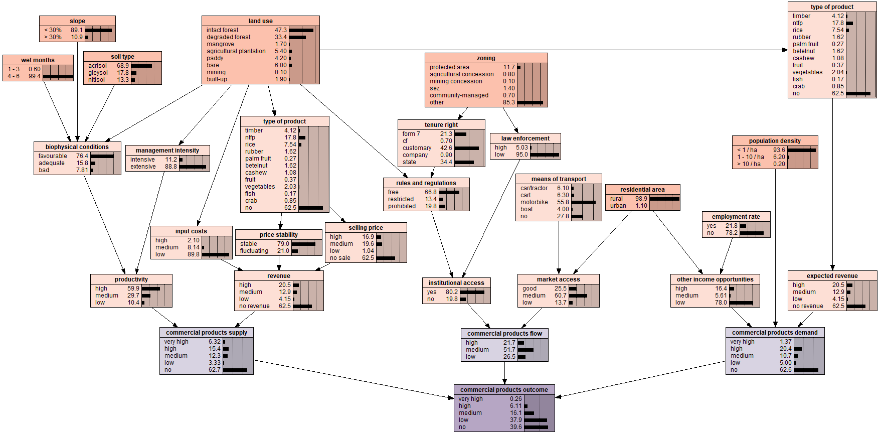
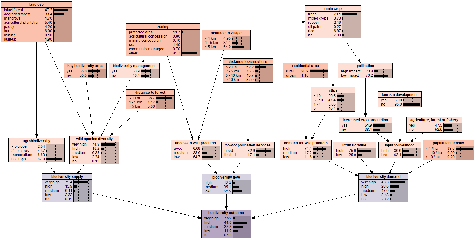
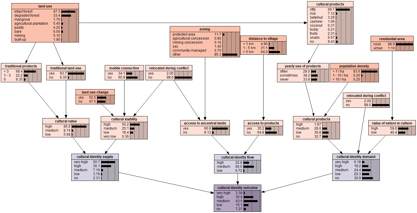
Political ecology provides a framework critically addressing how institutions, economic systems and social equity dimensions interplay and how these forces lead to decision-making processes transforming ES and their access. Using a political ecology lens, Kull et al. (2015) warn against the idea that ES is a taken-for-granted concept. Rather, ES is a social construct often taking a neo-liberal environmental commodification (Robertson, 2011) serving different protagonists’ interests. These interests in turn affect choices of boundaries, scales, and definitions leading to opposing interventions. Being aware of this critical perspective, this study further builds on the ES concept (Costanza et al., 1997; Costanza et al., 2017) that considers nature’s benefits to people in the form of provisioning, regulating and cultural services quantification. We selected three representative ES for which comparable models had been established in a previous study (Feurer et al., 2021): Commercial products, biodiversity, and cultural identity.
2.3 Developing scenarios
We followed the approach described by Martinez-Harms et al. (2017) that develops scenarios in several steps: i) defining the scope of the scenarios, ii) identifying key drivers of change, iii) constructing qualitative scenario storylines, and iv) quantifying scenarios for ES outcomes.
Defining the scope of the scenarios
We first selected three ES (commercial products, biodiversity, cultural identity) according to the following criteria: Local importance; minimum of one provisioning, regulating, and cultural service each; sensitivity of the ES to changes in political structures and respective land use policies. The geographic scope for the scenarios was determined by our study area in Tanintharyi Region, a forest frontier where the authors have worked for several years. While a smaller scale (township or village level) would not be able to provide for this diversity of land uses and tenurial claims, a larger scale (regional or national) would bear the risk of obscuring results. In terms of temporal scale, we decided on a period of ten years, which allows for changes in land use to be visible.
Identifying key drivers of change
For ES outcomes, we identified key drivers of change out of the most sensitive variables included in the models as described in Feurer et al. (2021). We selected the following key drivers that are directly affected by political agendas and land-related policies: land use, zoning, land tenure, access to ancestral lands, agricultural productivity, agrobiodiversity, demand for non-timber forest products, and socio-economic factors.
Constructing qualitative scenario storylines
Through an iterative process involving all authors and a complementary literature review, we constructed fitting qualitative storylines for three simplified, distinguishable scenarios that are prevailing and widely referred to models of governance in Myanmar. Two of them lean on the economic and environmental agendas of previous political regimes (unitary state, military regime) and one on a hypothetical governance structure (federal democracy) that has been pushed by various ethnic groups for decades but has not yet come to fruition. The initial qualitative storylines are as follows:
S1 Military regime: This scenario assumes that the military consolidates its power in the long term and, as it has previously done, uses land appropriation and exploitation of natural resources for territorial control and business relations.
S2 Unitary state: This is the ‘business-as-usual’ scenario of a pre-coup democratic government. Governance structures are very centralized and development objectives are followed through a market-driven economic system.
S3 Federal democracy: This scenario considers a hypothetical federal democratic system with a highly decentralized governance structure. It assumes strong community control over their territories (self-governed villages) with sustainable management and conservation of resources and economic development as twin objectives.
According to Berg et al. (2016), using detailed questionnaires with expert stakeholders can be a cost and time effective approach that supports the elaboration of plausible and relevant scenarios. Given the limited data available to quantitatively assess political scenarios and the need for in-depth knowledge on political institutions, processes, and the historical local context overall, we therefore decided to carry out an expert survey (Atkeson et al., 2016) to validate these initial storylines and better understand their effects on land use and land tenure in the study area.
We used the Unipark tool to develop a semi-structured online questionnaire (Annex I) asking how each scenario, in a time frame of ten years, is expected to affect the following indicators: land use, zoning, land tenure, access to ancestral lands, agricultural productivity, agrobiodiversity, intrinsic value of nature, as well as a number of socio-economic factors. For all spatial indicators, respondents were provided with the current extent and had to estimate the change on a scale from − 10 (decrease) to + 10 (increase). The questionnaire also included an estimation of the likelihood of each political governance system to be in place in two and ten years from now. The online survey was pre-tested and then sent to a total of 32 experts in the field of natural resources, land use and land governance in Myanmar. Through email notification, they were invited to fill in the questionnaire and add additional comments to the scenario storylines. Ten experts completed the questionnaire. They included two female and eight male experts between the age of 26 to 58. Six of them are Myanmar nationals, while the others have worked in Myanmar for five years or more. All of them have several years of professional expertise in forest management and/or environmental governance.
The current political crisis in Myanmar as well as the Covid-19 pandemic limited the extent of the survey. Several key stakeholders were unavailable or did not have sufficient internet access. Potential experts working for the previous government and/or the current regime had to be excluded due to the sensitivity of some of the questions and some preferred not to respond due to security issues although responses were anonymized. Also, with a specific type of knowledge demanded, some stakeholders did not feel confident to respond to the survey. It can be assumed that they would have been more inclined to respond in person, had that been possible. It should, however, be noted that similar challenges with stakeholder responses were faced even in a non-fragile context (Berg et al., 2016). Collecting data in conflicting areas, with the limitations it entails can nevertheless validate and shed light on important political processes and environmental outcomes.
Quantifying scenarios for ES outcomes
The qualitative scenario storylines including changes in land use and tenure (presented in Chap. 3.1) were then translated into plausible quantitative scenarios. Thereby, we modified the three pre-existing ES models (Annex II) in a slightly amplified way to allow for comparison across scenarios. Assumptions made for the main indicators are listed in Table 1.
Table 1
Model assumptions for each political scenario (S1 – S3)
| Indicator | Classes | BAU | S1 | S2 | S3 |
| | | surface area (%) |
| land use | intact forest | 47 | 30 | 40 | 48 |
| degraded forest | 33 | 30 | 30 | 31.5 |
| mangrove | 2 | 1 | 1.5 | 2 |
| agricultural plantation | 5 | 22 | 15.5 | 6 |
| paddy | 4 | 5 | 4 | 4.5 |
| bare | 6 | 8 | 5.5 | 5 |
| mining | 1 | 1.5 | 1 | 0.5 |
| built-up | 2 | 2.5 | 2.5 | 2.5 |
| total | 100 | 100 | 100 | 100 |
| zoning | protected area | 12 | 9 | 16 | 16 |
| agricultural concession | 1 | 10 | 6 | 1 |
| mining concession | 1 | 2 | 1 | 0 |
| special economic zone | 1 | 1 | 1 | 1 |
| community-managed area | 1 | 1 | 4 | 12 |
| other | 85 | 78 | 72 | 70 |
| total | 100 | 100 | 100 | 100 |
| tenure right | form 7 | 22 | 0 | 31 | 49 |
| community forestry | 1 | 1 | 4 | 6 |
| customary | 44 | 28 | 23 | 17 |
| company | 8 | 12 | 7 | 1 |
| state | 27 | 60 | 35 | 27 |
| total | 100 | 100 | 100 | 100 |
| access to ancestral lands | yes | 91 | 35 | 83 | 89 |
| no | 9 | 65 | 17 | 11 |
| total | 100 | 100 | 100 | 100 |
| agricultural productivity | high | 60 | 41 | 79 | 83 |
| medium | 30 | 30 | 16 | 13 |
| low | 10 | 29 | 5 | 5 |
| total | 100 | 100 | 100 | 100 |
| agrobiodiversity | > 5 crops | 3 | 2 | 4 | 4 |
| 2–5 crops | 2 | 6 | 10 | 6 |
| monoculture | 8 | 23 | 9 | 4 |
| no crops | 87 | 70 | 77 | 86 |
| total | 100 | 100 | 100 | 100 |
The quantitative scenarios were used to model the supply of and access to commercial products, biodiversity, and cultural identity from the perspective of rural communities (presented in Chap. 3.2). It is worth mentioning that rural communities are not homogenous and differ in terms of their ethnicity, values and livelihoods. In this study, they are considered one stakeholder group as they are local ES users and have similar rights over land. Nevertheless, customary and informal use of natural resources is widespread particularly in contested and remote border areas.